Cape Poge Bay Fishing Spot
- Public Fishing: Yes
- Last Modified By: carpmaster on 08/13/09 07:14 PM
- Ask about Cape Poge Bay in our Fishing Forums
Photos
Fish Species
Comments
-
Have you fished at Cape Poge Bay? Be the first to comment on this fishing spot.
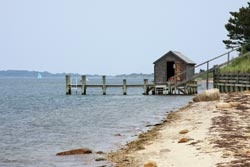
Cape Poge Bay Description
Chappaquiddick Island's eastern edge is a barrier beach formed thousands of years ago by offshore currents that deposited tons of sand. Today this beach extends for seven miles from Wasque Point past the Cape Poge Lighthouse to the Gut. Tidal waters support extensive salt marshes, especially around Poucha Pond. The Cedars is a grove of century-old, low-growing eastern red cedars sculpted by salt spray and wind. Cape Poge Elbow is home to a gull rookery and nests of piping plovers, least terns, and oyster catchers. West of the dunes lies Cape Poge Bay, where calm, clear waters serve as a nursery for finfish and shellfish. Powerful currents push through the Gut, flushing Cape Poge Bay with oxygen-rich water and attracting striped bass, bluefish, bonito, and albacore. During the early 1800s, the waters around Martha's Vineyard were among the busiest in the world. Cape Poge Lighthouse was built in 1801 to guide ships around the point. The years since 1801 have seen two reconstructions. The present white wooden structure was built in 1893; it is sixty-five feet above sea level and has a six-second flashing white light, which is visible for nine miles. The most remote place to paddle is Cape Poge Bay, located on the northern tip of Chappaquiddick. Here sea gulls, and an occasional scallop fisherman, may be your only companions in this undeveloped “almost pond” (a narrow channel is the only opening to Nantucket Sound). There are plenty of terrific places to swim and sun and fish.